
The problem
Avalanche forecasts rely on snowpack data from a limited number of points. The slopes where avalanches release are rarely among them.
Automated stations are placed on flat, accessible sites. Observers go where it is safe to go. Steep, wind-loaded release zones are where both reach their limits.
Wind and terrain redistribute snow over short distances, so snow depth on a slope can differ strongly from the nearest station. A single point cannot capture that pattern.
Forecasters close the gap with models, interpolation and experience. What is missing is a direct, spatial measurement of the snowpack in the terrain that matters.
Goals
-
Goal 1 · Fly
A drone that works in alpine winter conditions
More than 20 minutes of flight at −20 °C and 50 km/h wind and up to 3,000 m above sea level.
-
Goal 2 · Measure
Snow depth to ±5 cm, across whole slopes
Pre-planned, repeatable flight paths, so the same slope can be surveyed throughout a season.
-
Goal 3 · Validate
Data that holds up against ground truth
Every survey is checked against manual measurements and a snow-free terrain model at selected reference sites.
-
Goal 4 · Deliver
Output that models can use directly
Georeferenced, quality-checked and documented, in formats that forecasting and research models already work with.
-
Goal 5 · Look inside
Snowpack stratigraphy across whole release zones
Avalanche stability is decided inside the snowpack, in its layers and weak layers. Today that structure is measured in manual snow profiles, one pit at a time. Our long-term goal is to measure it from the air with ground-penetrating radar, repeatedly through a season.
Why we take this on
The problem sits between airframe design, sensing, data engineering and regulation. Our team covers all four.
Measurement accuracy depends on how stable the drone flies, which sensor it carries and how the data is processed. We work on all three in one team, so a change in one part is checked against the others right away.
-
Hardware to data
Mechanical engineering, physics, data engineering, law and economics. Each part of the chain has an owner.
-
Built at ETH
We develop at the ETH Student Project House, with access to its workshops, prototyping tools and coaching.
-
Users first
Before we fix the sensor and data format, we talk to avalanche services, ski areas, hydropower operators and researchers about what they actually need.
How we solve it
- Snow depth
Winter surface minus summer terrain
The drone maps the snow surface in winter. Subtracting a snow-free terrain model of the same slope, recorded in summer, gives snow depth for every point.
Snow surface, winter flight Terrain, snow-free (summer) Δh = snow depth - Airframe
Vertical take-off, fixed-wing cruise
A fixed-wing VTOL drone, designed and built by the team ourselves. Tilting rotors let it take off and land vertically on steep terrain, then fly efficiently like an aircraft. Because we build the drone ourselves, it is modular: payload, propulsion and electronics can each be adapted or swapped. This lets us change the sensor, from laser to LiDAR to ground-penetrating radar, and improve individual parts without rebuilding the whole aircraft.
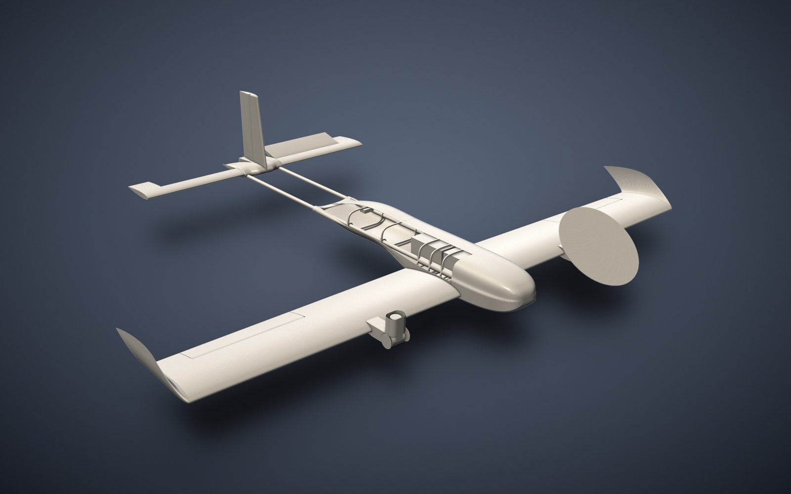
Current CAD draft of the aircraft. Concept status November 2026, not final. - Sensor
Laser first, LiDAR next
The first prototype measures with a laser rangefinder to prove the method from flight to snow-depth map. The next version carries LiDAR and uses the same processing chain. The airframe is sized for heavier payloads than camera-based survey drones carry, so ground-penetrating radar can be added later.
- Repeat flights
Same slope, same path, across the season
Pre-programmed flight paths make surveys comparable, so new snow and wind loading show up as change over time.
- Safe operation
Manual override and layered failsafes
A pilot can take control at any time. Multiple failsafes handle loss of connection. All flights follow Swiss drone regulations.
- Data pipeline
From raw measurements to a usable map
Distance, position and orientation are synchronised by GPS time and georeferenced in the Swiss coordinate system. The data is then filtered, checked against reference points and delivered as standard geodata.
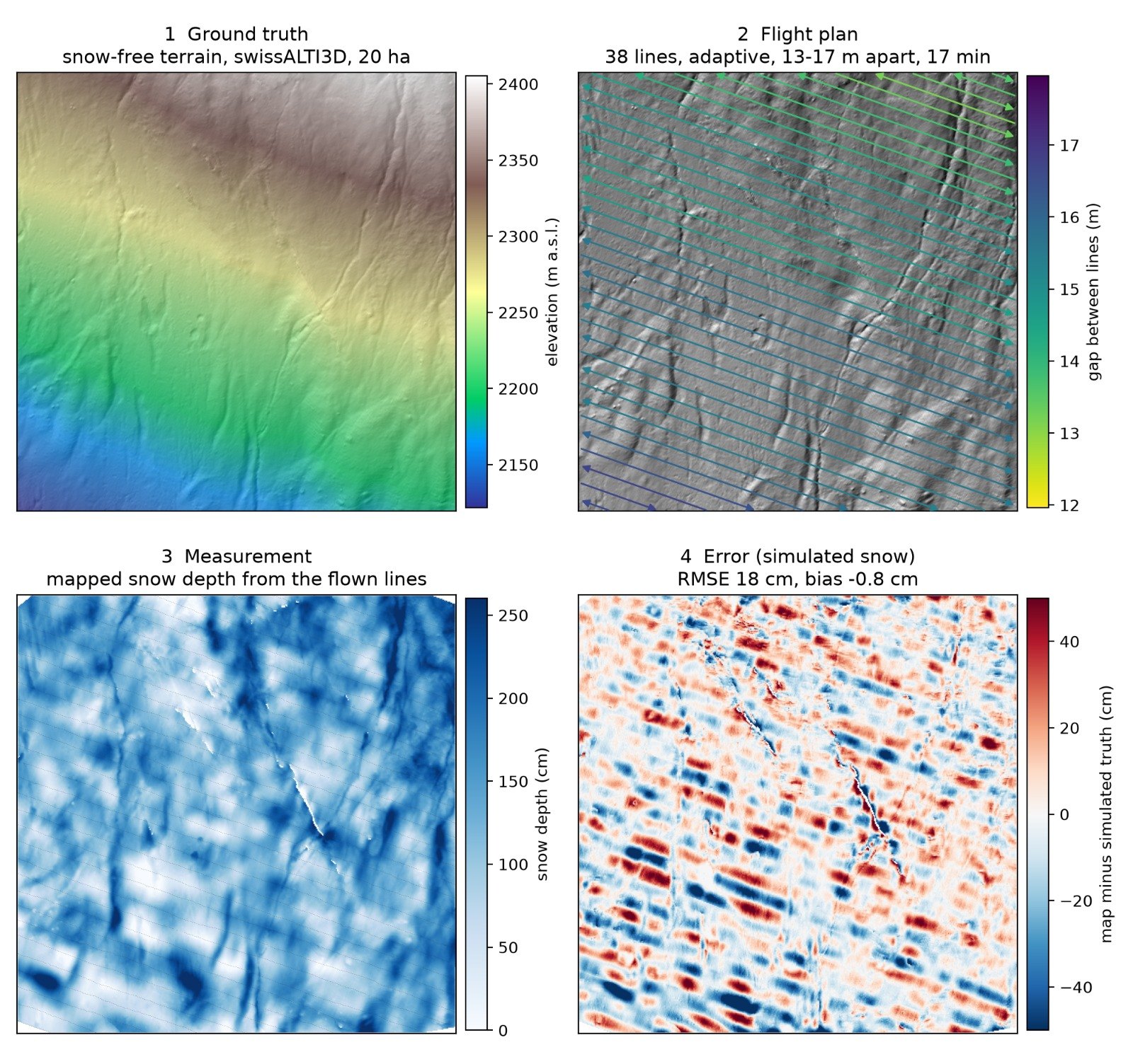
Simulated run of the data pipeline on real terrain (swissALTI3D, 20 ha): reference terrain, flight plan, mapped snow depth and deviation from the simulated snowpack. - Next step
Below the surface: stratigraphy
Once snow depth is validated, the same platform carries ground-penetrating radar to map layering and weak layers inside the snowpack, checked against manual snow profiles.
Timeline
-
Sep 2026
Project start
Team formed, requirements and work packages defined.
-
We are here
Until Dec 2026
First prototype
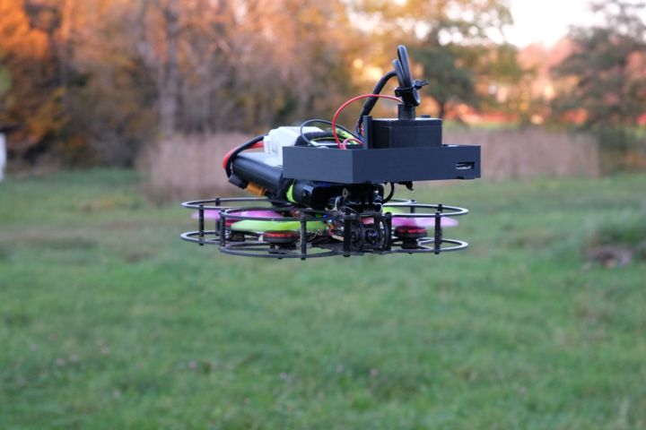
Concept chosen: a fixed-wing VTOL. Building the airframe, sensor logger and data chain. First flights before Christmas, continuing in early January.
-
Winter 2026/27
Field campaign
Many flights over real snow. Testing hardware, software and the data chain.
-
Spring/Summer 2027
Version 2
Redesign based on the field data. Improved and validated system.
-
Summer/Autumn 2027
Ground truth
Snow-free terrain models and reference measurements at selected sites.
-
Winter 2027/28
Data for models
Regular surveys at the reference sites. Data fed into forecasting and research models with partners.
-
From 2028
Stratigraphy
Ground-penetrating radar on the platform. Snowpack layering measured from the air.
Team
-
Alexander Althaus
BSc Mechanical Engineering, ETH Zurich
Airframe concepts and design, propulsion hardware.
-
Julian Chung Lor Zielonka
MSc Medical Physics · BSc Physics, ETH Zurich
Sensor payload, data acquisition, stabilisation and control software.
-
Olivier F.
BSc Law & Economics, University of St. Gallen (HSG)
Flight-control hardware, project coordination, finance and the regulatory path.
-
Moritz Mössner
Data Engineer · BSc Biodiversity, University of Zurich
Data pipeline, quality assurance, handover to avalanche models.
Work with us
What we are looking for
- Avalanche services, ski areas, hydropower operators and researchers who can tell us which data they need, and in which format.
- Test sites with access to terrain and existing reference data.
- Hardware and funding partners for the prototype and the field campaign.
- Advice on alpine flight operations and the regulatory path.

